Wet shelter. No dry bedding.
OCHA’s December 2025 reporting describes flooded tents and the loss of bedding, clothes and temporary shelter. A storm can take away several basic protections at once.
OCHA · 18.12.2025WINTER IN GAZA · CONTEXT & EVIDENCE
For a family in a worn tent or a damaged home, a winter storm can mean losing the last dry place to sleep. Preparation is about shelter, warmth, health and keeping help within reach.
RESEARCH SPOTLIGHT · 24 SEPTEMBER 2026
Mapped active displacement sites classified as high flood risk.
Brief, p. 5Reported residents in those high-risk sites.
Brief, p. 6, Table 5Of the high-risk site population is in Khan Younis and Deir al-Balah combined.
Brief, p. 9These figures describe the sites in the report’s mapped dataset, not a complete census or confirmed flooding. Site populations may have changed since the data extract of 9 September 2026.
FROM ELIAS BERSHADSKY’S RESEARCH
These are original figures extracted from Elias Bershadsky’s Gaza Flood Exposure and IDP Site Risk Operational Brief, dated 24 September 2026. The original colours, legends and map-source credits are preserved. Open either image at full size to read its detail.
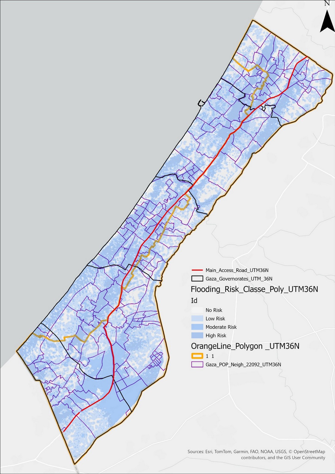
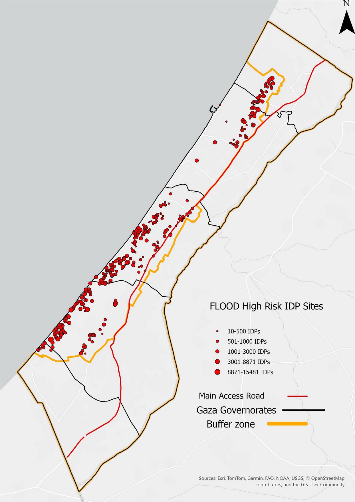
Credit: Elias Bershadsky, 2026. Basemap and input-source credits remain visible within the figures. These are planning maps of potential exposure, not images of an observed flood, real-time conditions or a storm forecast.
OCHA’s December 2025 reporting describes flooded tents and the loss of bedding, clothes and temporary shelter. A storm can take away several basic protections at once.
OCHA · 18.12.2025UNICEF documented child deaths during severe winter conditions and described tents collapsing or blowing away. Warm clothes and blankets matter, alongside safe shelter.
UNICEF · 30.12.2025UNICEF links winter flooding to damaged water and sewage systems and serious public-health risks. Drainage, functioning pumps and access to sanitation are part of protection.
UNICEF · 30.12.2025OCHA reported collapses of already damaged buildings and rain-related restrictions on humanitarian routes. Shelter repairs require local professional judgement; a roof alone is not a guarantee of safety.
OCHA · 18.12.2025This page explains the campaign context. It is not a weather alert, a medical guide or instructions for building or evacuation.
The brief compares mapped flood-risk areas with reported populations at displacement sites. It also contains a separate neighbourhood model: 1,882,821 people, or 89.7% of a 2.1 million baseline, are estimated to live in low, moderate or high mapped risk areas. That is not the number of people at high risk, and it must not be added to the site figures above.
Source: Bershadsky, 24 September 2026, pp. 1–3; methods and limitations, p. 10.
“Risk classes indicate potential exposure, not observed flood depth”
Elias Bershadsky · Operational Brief, p. 10 · Exact English excerpt
In practical terms, the author recommends verifying drainage, shelter condition, access and evacuation options at high-risk sites, updating population information and responding to short-range forecasts and conditions on the ground. This is the report’s operational interpretation, not evidence that flooding has already happened.
Paraphrase of Operational implications, p. 10.
The brief credits OCHA oPt (4 September 2026) for its population baseline, UNICEF’s Gaza Service Mapping V2.0 with an active-site extract dated 9 September 2026, and project spatial layers for risk, boundaries and access roads. Those are the author’s stated inputs; the site-level numbers shown here are results of this independent analysis, not figures issued directly by the UN.
Source references appear on p. 10 of the PDF. The numeric callouts link to their exact pages. Only the passage in quotation marks is a direct quotation; other descriptions are summaries.
WMO’s 3 September 2026 update expects a strengthening El Niño with global effects into 2027, but cautions that its strength alone does not determine impacts in a particular place. The attached brief likewise treats El Niño as a possible risk amplifier, not a Gaza-specific rainfall forecast.
RELATED RESEARCH · MITVIM
Mitvim · May 2026 · underlying data through September 2025
Mager’s study connects construction debris with damaged infrastructure, pollution and hazardous materials, including asbestos and unexploded ordnance. It argues that debris treatment and water-system recovery must be planned together.
Our winter-campaign reading: safe access, drainage and shelter repairs cannot be separated from the surrounding infrastructure. This is a connection we draw for the campaign, not a flood forecast from the study. It is not guidance to collect or reuse rubble without specialist assessment.
Source: Adi Mager, section 3.5, English PDF pages 30–31; data-date clarification on PDF p. 2.
Read the study’s English introductionMitvim / EcoPeace expert process · March 2024
A separate recommendations paper explains the interdependence of energy, water, wastewater and health. Its wastewater chapter describes damaged sewage networks and pumps, and the need for sanitation at temporary population centres. This is historical infrastructure context, not an assessment of conditions in October 2026.
Read the wastewater chapter · English PDF, p. 12LOOKING BACK · WINTER 2025–26
Dated reporting provides context, not a description of today’s conditions. These reports describe Gaza more broadly; they are not reports of GSN’s own activities.
OCHA oPt · 18.12.2025
Reporting on Storm Byron, damaged shelters, building collapses and access challenges.
Read the OCHA reportUNICEF · 30.12.2025
A statement on child deaths, unsafe shelter, drainage and the urgent need for winter supplies.
Read the UNICEF statementAssociated Press · 28.12.2025
A news report from Khan Younis on flooded camps and families trying to stay dry in worn tents.
Read the AP articleDry bedding, stronger tents, rainproofing where safe, drainage, warm clothing and blankets: this is the practical focus of Before the Rains.
See our last winter campaign